
Deforestation forecasting powered by the latest AI research
Know where you'll lose forest, before it happens. Combining satellite/UAV data with cutting-edge machine-learning techniques, we provide risk maps at up to 30m resolution that enable you to act, not just react.
Reactive monitoring is becoming a liability.
Regulators, registries, and buyers are no longer satisfied with evidence of damage already done. Staying reactive exposes you to credit invalidation, failed due diligence, and reputational risk — at the moment forest assets face the sharpest scrutiny in a decade.
EUDR enforcement is creating hard deadlines for geolocated, deforestation-free supply-chain evidence.
Carbon-market integrity frameworks increasingly require dynamic, forward-looking baselines — not static historical matching.
Investor and buyer diligence on nature-based assets is tightening; lagging indicators no longer pass review.
What we offer
Combining our proprietary deep learning models with large-scale Earth observation data, we transform satellite imagery into actionable risk insight tailored to our clients’ needs.
Spatial Risk Maps


Actionable Insights
Tailored Solutions


You will receive actionable risk maps at up to 30m resolution, so you can determine exactly where to prioritize areas for conservation efforts and optimize resource allocation — whether protecting biodiversity hotspots or preventing illegal activities in remote regions.
Annual Risk Forecasts
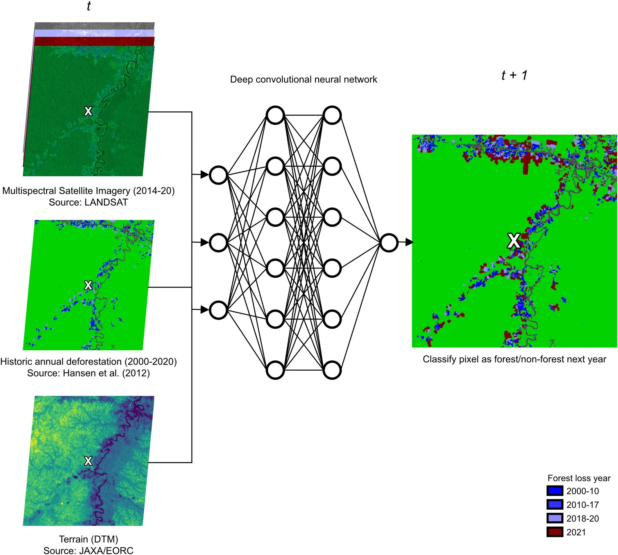
Where is deforestation most likely in the next 12 months? Our models learn from historical patterns and multi-year satellite imagery to predict emerging threats - including illegal logging, mining expansion, and agricultural pressure.
Our predictive models not only provide alerts for near-term deforestation but also help inform long-term conservation strategies by identifying key drivers of deforestation, such as proximity to new infrastructure or areas of agricultural pressure.
Our system is scalable to any tropical forest region globally, and tailored to the risk profile that matters most. From the Amazon to urban forest in Germany, we provide governments, NGOs, and private organizations with monitoring systems tailored to their specific environmental challenges and needs.
-
Get ahead of reversal risk before it threatens a buffer pool or surfaces at audit.
-
Price ecosystem assets on forward-looking risk instead of a backward-looking snapshot.
-
Demonstrate risk-based due diligence across a full supply shed, not just a single plot.
Built for the people underwriting forest risk.
Case Study
Biomass forecasting for next-generation carbon credits
We built and deployed an AI-driven biomass forecasting system that produces pixel level (~30m) risk maps for Wildlife Works, one of the world's leading REDD+ project developers.
The forecasting system now underpins EquitableEarth's M002 Terrestrial Forest Conservation Methodology worldwide, which entered public consultation in 2025 and is being adopted by REDD+ projects.
Wildlife Works / EquitableEarth

Related Research
“Using deep convolutional neural networks to forecast spatial patterns of Amazonian deforestation”
Methods in Ecology and Evolution (2022)
13(11), 2622-2634
Ball, J. G. C., Petrova, K., Coomes, D. A., & Flaxman, S. .
See Also:
Decision Support
End-to-end monitoring systems that are transparent, effective, and ready for third-party review.
Let’s discuss your forest.
Reach out to find out more about how forestmap.ai can help your organization.
info@forestmap.ai
+44 (0)7986 882 740
By submitting this form, you acknowledge our Privacy Policy.
